How do I find my way around London?
- CityMapper phone app – this is designed for easy trip planning around major capitals and will contain the latest travel alerts and information
- TfL planner – https://tfl.gov.uk/plan-a-journey/ Don’t forget to get a Student 18+ Oyster Card for reduced prices on Travelcards! https://tfl.gov.uk/fares/free-and-discounted-travel/18-plus-student-oyster-photocard
- London tube map: https://tfl.gov.uk/maps/track/tube
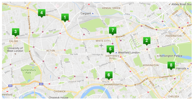
- Woodward Buildings
- Nearest large supermarket (Asda)
- North Acton Tube station (central line) – local Sainsbury and Tesco available by the station exit
- Park Royal Leisure Park (here you can find cinema, bowling, trampolining, restaurants and shops with student discounts)
- North Acton Playing Fields (Cloister Road just off Eastfields Road)
- Wormwood Scrubs Park (park run events on Sat!)
- Acton Main Line (direct Overground trains to Paddington)
- Central Middlesex Hospital (+ 2 units: Patrick Clements Sexual Health Clinic and Park Royal Mental Health Clinic)
- The Castle pub
- Nearest bus stops
- Woodward Halls, North Acton
- Notting Hill: Home to the famous Portobello Road Market.
- Ealing Broadway: Home to many restaurants, pubs, bars, shops and parks.
- Park Royal
- Shepherds Bush. Music events at Shepherds Bush Empire. Shepherd’s Bush Market (shops) Westfield (biggest mall in London).
- Hammersmith: Shops and bars, selection of pubs right on the River Thames.
- White City Campus: The site of Imperial’s newest research campus.
- South Kensington Campus
Who can you speak to to find out more about our local area?
Our Community Champion, Naima! The community champion works with other members of the local community to provide students in North Acton with the best possible experience, and will be available to help students explore the local area throughout the year!